Prices
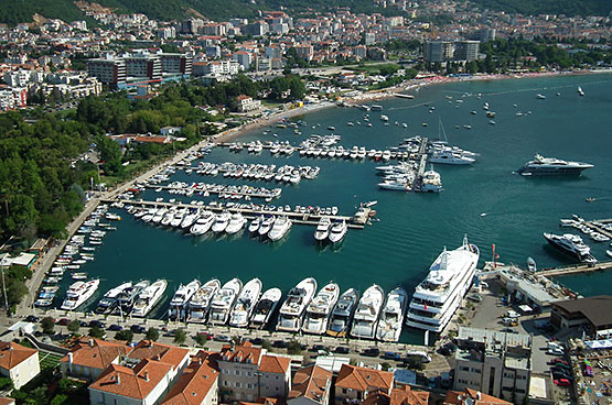
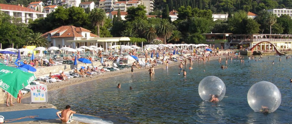
Ulcinj
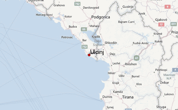
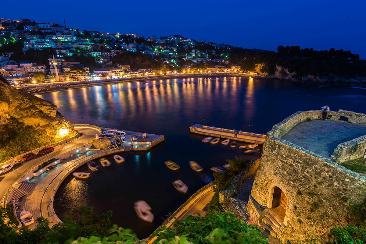
Ulcinj is an ancient seaport. The wider area of Ulcinj has been inhabited since the Bronze Age, based on dating of Illyrian tombs (tumuli) found in the village of Zogaj, in the vicinity of Ulcinj. The town is believed to have been founded in the 5th century BC by colonists from Colchis, as mentioned in the 3rd century BC poem by Apollonius of Rhodes. Illyrians lived in the region at the time as there are traces of immense Cyclopean walls still visible in the old Citadel.
All the way in the pre-medieval period, Ulcinj was known as one of the pirate capitals of the Adriatic Sea. This is also seen during the later period of Illyrian Kingdom. Inhabitants of Ulcinj were known before time of Christ, especially from 20 BC to around 300 AD, to be very confrontational to those who were foreigners to their land they were especially meticulous about border disputes as well.
In the catastrophic earthquake on April 1979 the town suffered severe damages however, it was just a couple of years later that it was renewed thanks to the solidarity of the citizens
During the 2006 referendum on Montenegro's independence, the Ulcinj municipality voted overwhelmingly to leave the State Union of Serbia and Montenegro. This was partly due to the region's large Albanian population. Other regions of Montenegro with large minority populations also voted in favor of independence.
Budva
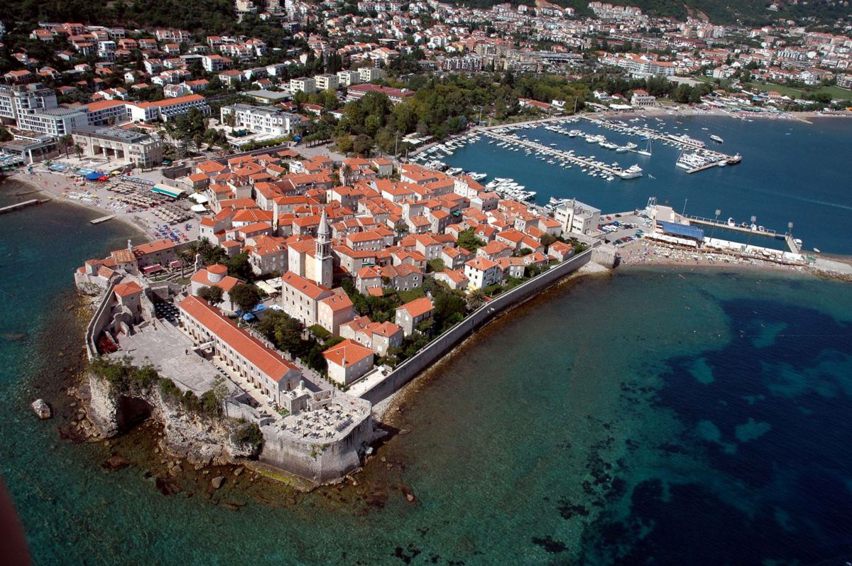
Budva, pronounced [bûːdv̞a] or [bûdv̞a]) is a Montenegrin town on the Adriatic Sea. It has around 14,000 inhabitants, and it is the centre of Budva Municipality. The coastal area around Budva, called the Budva riviera, is the center of Montenegrin tourism, known for its well preserved medieval walled city, sandy beaches and diverse nightlife. Budva is 2,500 years old, which makes it one of the oldest settlements on the Adriatic coast.There is vast archaeological evidence that places Budva among the oldest urban settlements of the Adriatic coast. Substantial documentary evidence provides historical references dating back to the 5th century BC.
The Old Town of Budva is situated on a rocky peninsula, on the southern end of Budva field. Archaeological evidence suggests that Illyrian settlement was formed on the site of the Old Town before Greek colonization of the Adriatic. While the site was permanently settled since Roman era, most of existing city walls and buildings were erected during the Venetian rule.The entire town is encircled with defensive stone walls. The fortifications of Budva are typical of the Medieval walled cities of the Adriatic, complete with towers, embrasures, fortified city gates and a citadel.
Gambling tourism is also popular in Budva, as many hotels have attached casinos are particularly popular among international gamblers, but other large hotels have also attracted players from European countries. The 2006 James Bond film Casino Royale is partly set in the eponymous casino thus giving a boost to Budva's profile as a gambling destination.
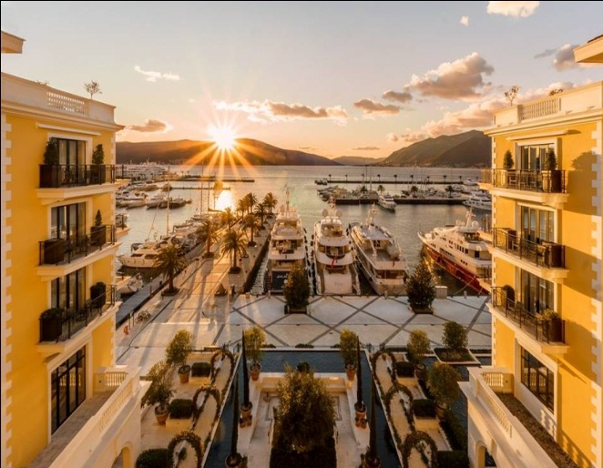
Budva marina, nestled to the north of the Old Town city walls, contributes to the image of Budva as a nautical tourism destination. Luxury yachts dominate marina berths during the summer, overshadowing small fishing vessels owned by the locals. Budva marina was host to periodic boat shows, but in recent years it has been losing primacy to the larger and more luxurious Porto Montenegro. Budva was the host of the Class 1 World Powerboat Championship Grand prix in May 2008.
Kotor
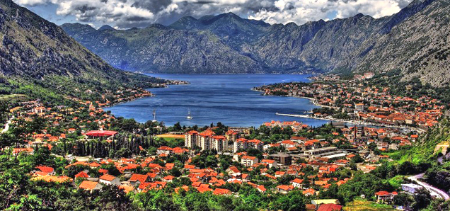
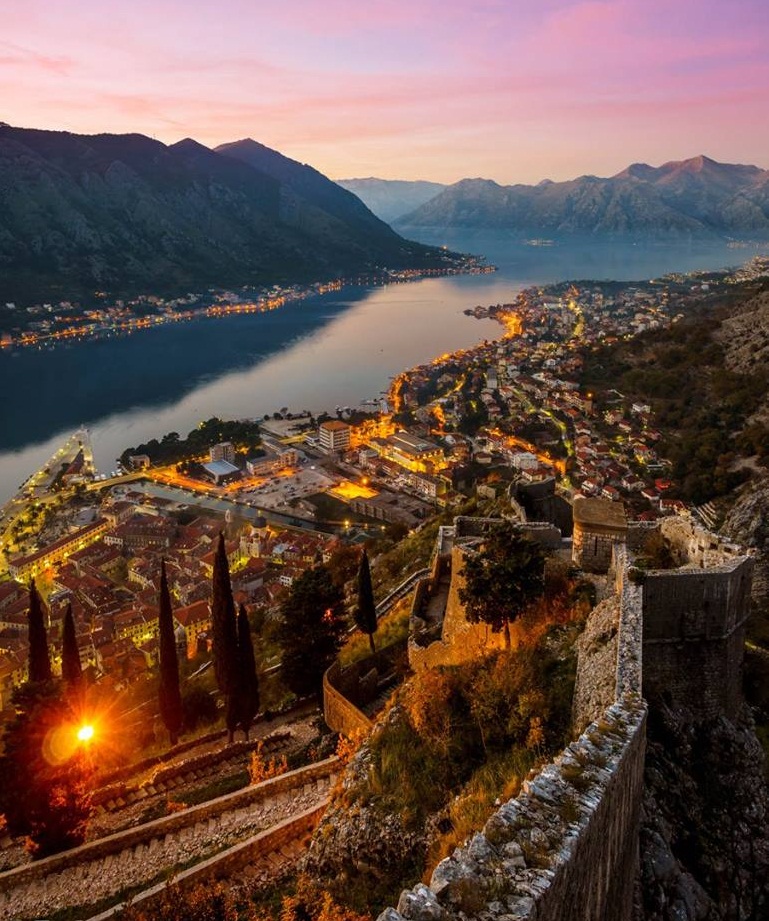
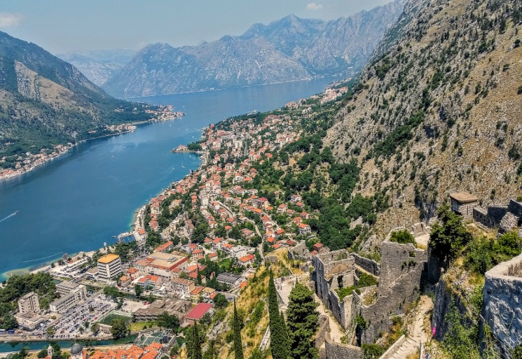
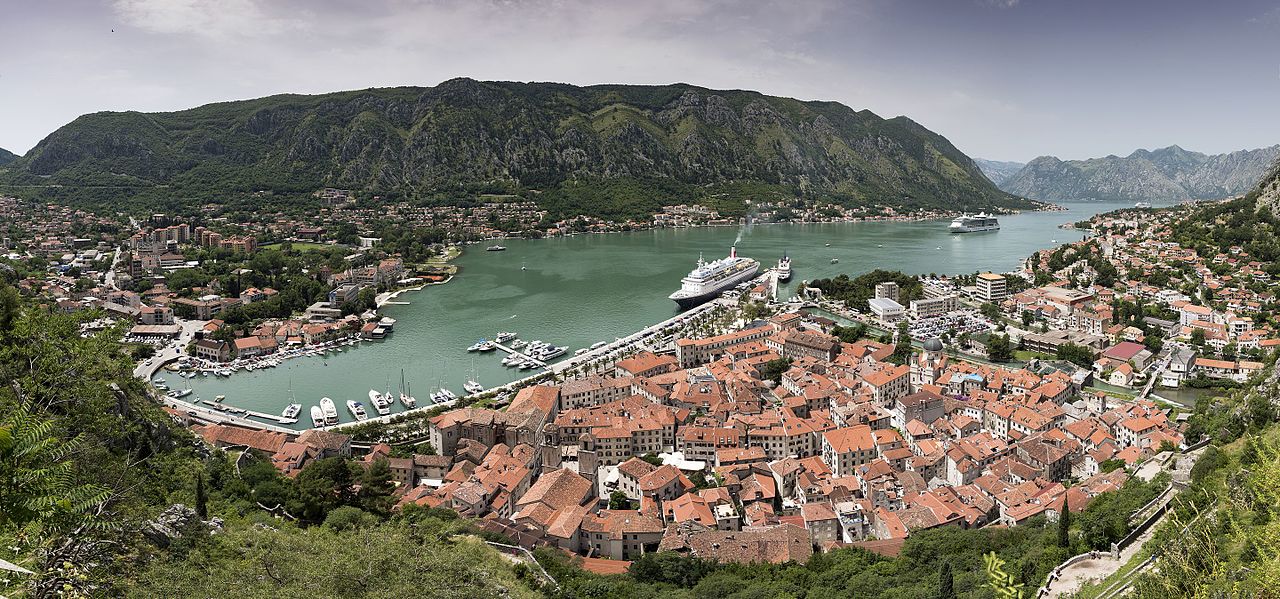
Kotor the old Mediterranean port of Kotor is surrounded by fortifications built during the Venetian period. It is located on the Bay of Kotor (Boka Kotorska), one of the most indented parts of the Adriatic Sea. Some have called it the southern-most fjord in Europe, but it is a ria, a submerged river canyon. Together with the nearly overhanging limestone cliffs of Orjen and Lovćen, Kotor and its surrounding area form an impressive and picturesque Mediterranean landscape.
In recent years, Kotor has seen a steady increase in tourists, many of them coming by cruise ship. Visitors are attracted both by the natural beauty of the Gulf of Kotor and by the old town of Kotor. Kotor is part of the World Heritage Site dubbed the Natural and Culturo-Historical Region of Kotor.
Kotor, first mentioned in 168 BC, was settled during Ancient Roman times, when it was known as Acruvium, Ascrivium, or Ascruvium (Ancient Greek: Ἀσκρήβιον) and was part of the Roman province of Dalmatia. Kotor has been fortified since the early Middle Ages, when Emperor Justinian built a fortress above Acruvium in 535, after expelling the Ostrogoths
Kotor has one of the best preserved medieval old towns in the Adriatic and is a UNESCO world heritage site.[3] It is home to numerous sights, such as the Cathedral of Saint Tryphon in the old town (built in 1166), and the ancient walls which stretch for 4.5 km (3 mi) directly above the city. Sveti Đorđe and Gospa od Škrpijela islets off the coast of Perast are also among the more popular destinations in the vicinity of Kotor.
Dubrovnik
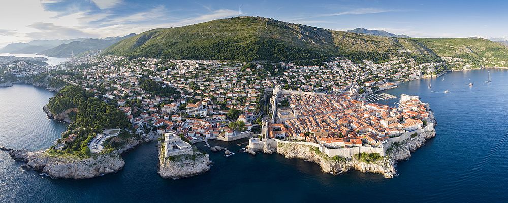
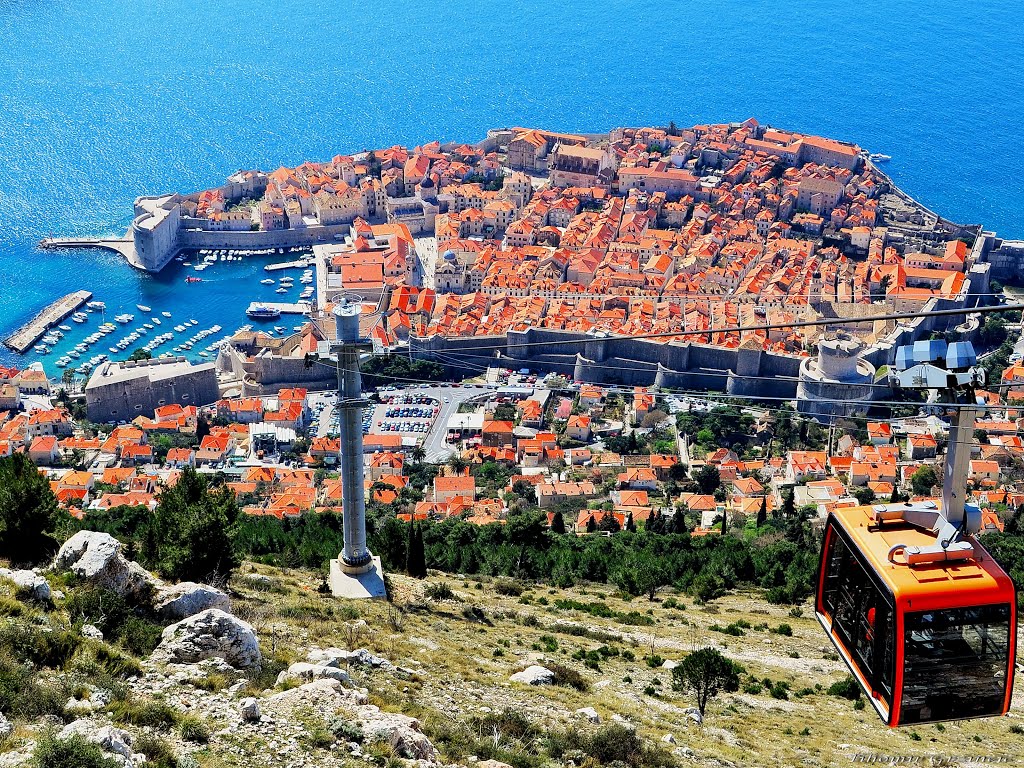
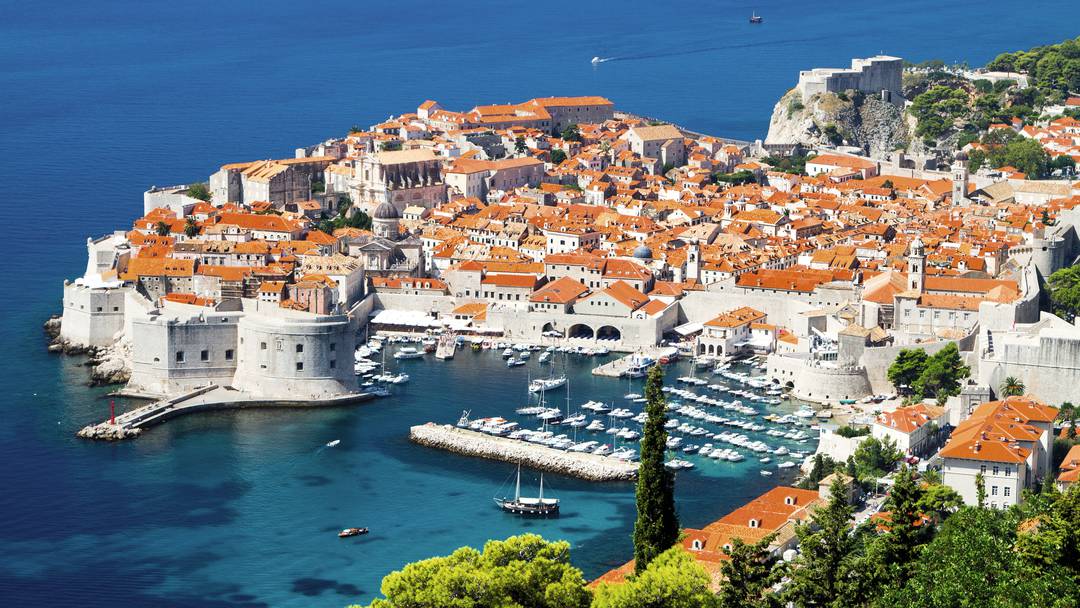
Dubrovnik is a city in southern Croatia fronting the Adriatic Sea. It's known for its distinctive Old Town, encircled with massive stone walls completed in the 16th century. Its well-preserved buildings range from baroque St. Blaise Church to Renaissance Sponza Palace and Gothic Rector’s Palace, now a history museum. Paved with limestone,. Dubrovnik ([dǔbroːʋniːk] ( also known by other names) in the region of Dalmatia. It is one of the most prominent tourist destinations in the Mediterranean Sea, a seaport and the centre of Dubrovnik-Neretva County. the city of Dubrovnik joined the UNESCO list of World Heritage Sites.
The prosperity of the city was historically based on maritime trade; as the capital of the maritime Republic of Ragusa, it achieved a high level of development, particularly during the 15th and 16th centuries, as it became notable for its wealth and skilled diplomacy.Although it was demilitarised in the 1970s to protect it from war, in 1991, after the break-up of Yugoslavia, The annual Dubrovnik Summer Festival is a 45-day-long cultural event with live plays, concerts, and games. It has been awarded a Gold International Trophy for Quality (2007) by the Editorial Office in collaboration with the Trade Leaders Club.
A feature of Dubrovnik is its walls (1.1 million visitors in 2016) that run almost 2 kilometres (1.2 miles) around the city. The walls run from 4 to 6 metres (13–20 feet) thick on the landward side but are much thinner on the seaward side. The system of turrets and towers were intended to protect the vulnerable city. The walls of Dubrovnik have also been a popular filming location for the fictional city of King's Landing in the HBO television series, Game of Thrones.
Kolasin
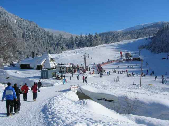
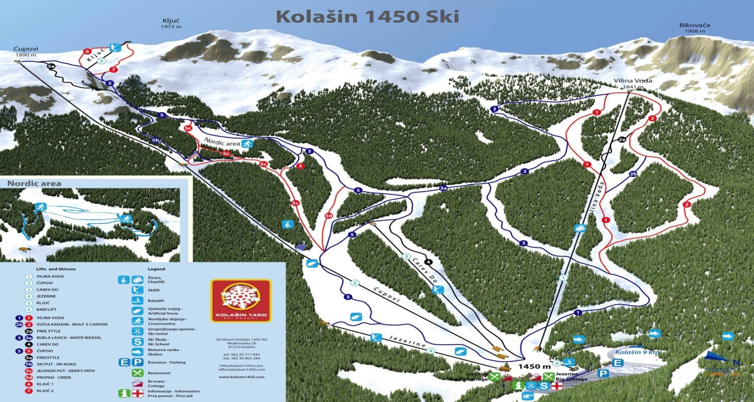
Kolasin is city on the North of Montenegro. Founded by Turks in 17th century, this small city is one of must visit places in Montenegro.
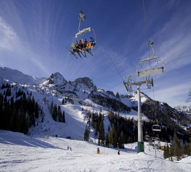
Kolašin is one of the centres of Montenegro's mountain tourism. Although Žabljak is considered more attractive destination, Kolašin has the advantage of being easily accessible by road and rail.
Kolašin is located on the foot of Bjelasica and Sinjajevina mountains, which offer great conditions for skiing. Because of Kolašin's altitude (954 m), the town is considered an air spa. A special attraction for tourists represents the Biogradsko Lake located in National park “Biogradska gora” which is one of three preserved virgin forest of Europe. The Biogradsko Lake is at 1094 m of altitude and around it there are walking paths.
Biogradska Gora national park is in the town's vicinity, and is considered a premium tourist attraction. The development of Kolašin as a tourist destination is bolstered by opening of luxury resort in town's center.
Kosovo
Republic of Kosovo (Albanian: Republika e Kosovës; Serbian: Република Косово / Republika Kosovo). Kosovo is landlocked in the central Balkan Peninsula. Its capital and largest city is Pristina.
In antiquity, the Dardanian Kingdom, and later the Roman province of Dardania was located in the region
Wine has historically been produced in Kosovo; both red and white. Currently the wine industry is successful and growing after the war in the 1990s. The main heartland of Kosovo's wine industry is in Orahovac where millions of litres of wine are produced. The main wines produced in Kosovo include Pinot noir, Merlot and Chardonnay. Kosovo exports wines to Germany and the United States
Tourism in Kosovo is characterized by archaeological heritage from Illyrian, Dardanian, Roman and Ottoman times, delicious traditional Albanian cuisine, architecture, religious heritage, unique traditions, and natural landscapes.
The New York Times recently included Kosovo on the list of 41 Places to go in 2011. In the same year, Kosovo saw a jump of about 40 places on the Skyscanner flight search engine which rates global tourism growth.
Kosovo's monuments are classified as unique common property for which the society is responsible to maintain them in order to transmit their authenticity to future generations .During the Kosovo War in 1998 to 1999, more than 500 monuments were systematically targeted by the Serbian state forces, where more than 80% of them were destroyed, burnt or damaged. In many of them, only the construction walls have remained.
Kosovo has always been considered as a country, where tolerance and coexistence in terms of religion and culture has been part of the society in the last centuries.
Gjakova — a well known city for its nightlife and historical monuments. Monuments include: mosques, churches, bridges, museums, landscape and hospitality.The clock Tower of Gjakova.
Peć— a city along the Peć Bistrica river. It is located near the Prokletije mountains. The center of the city is marked by different craftsmen shops, such as tailors, goldsmiths, leather tanners etc. Old mosques like the Bajrakli mosque and the Orthodox church, are part of the historical monuments of the city.[9]
Prizren — a town with a well-preserved Ottoman quarter, and a Roman-built castle. Prizren is located on the Prizreni River and is near the Šar Mountains. One of the monuments to see in Prizren are the Kaljaja Fortress as well as the Serbian Orthodox Our Lady of Ljeviš church.[10]
Novo Brdo- a municipality in central Kosovo. Novo Brdo offers its visitors various hiking and mountain-biking possibilities. Some archaeological localities of the medieval town include: the medieval castle, religious buildings, cemeteries etc.
Old castle in Novo Brdo
Ulpiana- an ancient city of Illyrian Dardania from the 2nd century in the Balkan peninsula. It is known to have been re-constructed by emperor Justinian I.\
.Via Ferrata Ari Is a metallic structire in vertical rock which enables people to climb the wall without being climbers. Via Ferrata date as structure from world war one. The one in Peć was built by Marimangat e Pejes in 2013 and 2014 with the support of donors. It has more than 100 stairs and the whole trip is around 3 kilometers.
White Drin Waterfall - located in the north of Peć. The White Drin is the largest spring in Kosovo.
Rugova Canyon - located in the North West of Peć, with extremely steep walls reaching possibly up to 300 meters.
Brezovica Ski Resort - a ski resort with an old infrastructure but great slopes, located in Šar Mountains National Park in Southern Kosovo.
Šar Mountains National Park- proclaimed in 1993 within the temporary boundaries of 39,000 hectare in South Western Kosovo. The Šar Mountains are a mountain range that border the Republic of Macedonia. The Šar Mountains are the home of many animal species, such as: bears, wolves, deers, and foxes.
Prokletije National Park- a proposed national park since 2001 in the area of the Prokletije Mountain Range in Western Kosovo and part of the larger Dinaric Alps.
Gadimlje Cave- an underground marmoreal cave in the village of lower Gadimlje near Lipljan that was discovered in 1969 by Ahmet Diti. It is famous for its Stalagmites and Stalactites.
Medieval Monuments in Kosovo, a combined UNESCO World Heritage Site including:
Patriarchate of Peć, this complex of four churches was built between 1230 and 1330 by the medieval Serbian royal Nemanjić dynasty. The church was the seat of the Serbian Patriarchate since 1302. It is considered to be of great national importance to Serbs and Serbia.
Visoki Dečani Monastery, and one of the most important monasteries of the Serbian Orthodox Church in Kosovo. It was built from 1307- 1328.
Gračanica monastery- was completed in 1321 by the Serbian King Milutin.The monastery is one of the most beautiful examples of Serbian medieval (14th century) ecclesiastical architecture. This is a UNESCO World Heritage Site.
Macedonia
Macedonia officially the Republic of Macedonia is a country in the Balkan peninsula in Southeast Europe. It is one of the successor states of the former Yugoslavia, from which it declared independence in 1991.
Macedonia has a transitional climate from Mediterranean to continental. The summers are hot and dry, and the winters are moderately cold.
Skopje, the capital and largest city, is situated in the northern part of the country on the Vardar River. Skopje has a long history that is evidenced by its many archaeological sites, such as Scupi and the Skopje Aqueduct, and the large number of Ottoman buildings and monuments, particularly in the Old Bazaar, such as Mustapha Pasha Mosque. Today, Skopje, with over 500,000 inhabitants, is becoming a modern city with museums and many cultural and sporting events.
Ohrid, an UNESCO World Heritage Site, is located in the southwestern part of the country on the eastern shore of Lake Ohrid. The town is perhaps the most popular tourist destination in the country, which is largely due to the beaches and atmosphere. However, Ohrid also has many historical monuments, such as Samuil's Fortress and the Antique Theatre.
Bitola, the second largest city, is situated in the southern part of the country. Like many cities in the country, Bitola has also had a rich history. Heraclea Lyncestis, one of the Republic of Macedonia's largest archaeological sites, is located in Bitola. The long history of Bitola is also exemplified by the town's many neo-classical buildings, Ottoman buildings and monuments, and old churches. The town is also a shopping destination; Širok Sokak, a pedestrian street, is filled with an endless amount of stores and restaurants.
Štip, the largest city east of the Vardar River, is located in the eastern part of the country. Štip has existed for at least 2,000 years which is showcased by its many archaeological sites, such as Astibo, Bargala, and Estipeon. The city is also home to the healing waters of the Kežovica Mineral Spa. Today, Štip is the main cultural and economical centre of eastern Macedonia.
Other cities and towns in the country, such as Kratovo, Kruševo, Prilep, Strumica, and Struga, have many attractions of their own
Albania
Tirana - Albanian: Tiranë; regional Gheg Albanian: Tirona) is the capital and largest city of Albania and as well the heart of Albania's cultural, economic and governmental activity. It is located on the western center of the country surrounded by hills with the Dajti Mountain on the east and a slight valley opening on the north-west overlooking the Adriatic Sea in the distance. Tirana is one of largest cities in the Balkan Peninsula and ranks 7th with a population of 800,000 Tirana is a city with a rich history dating from the Paleolithic times back 10,000 to 30,000 years ago to the present day. The oldest settlement located in the area of the city was the Cave of Pellumbas
Tirana is home to the largest cultural institutions of the country, such as the National Theatre of Albania and the National Theatre of Opera and Ballet of Albania, the Archaeological Museum, the Art Gallery of Albania, the Sciences Museum of Albania and the National Historical Museum. Among the local institutions are the National Library of Albania which has more than a million books, periodicals, maps, atlases, microfilms and other library materials. Tirana has five well-preserved traditional houses (museum-houses), 56 cultural monuments, eight public libraries and the National Library of Albania Biblioteka Kombëtare.[59] Since 2011, a Tourist Information Office was opened, located behind the National History Museum, with useful information on Tirana and Albania.
The largest Museum in Tirana is the National Historical Museum which details the history of the country. It was opened on 28 October 1981 and is 27,000 square metres (290,000 square feet) in size, while 18,000 square metres (190,000 square feet) are available for exhibitions. It keeps some of the best archeological finds in Albania, dating from Prehistory to the Ottoman period. In the stands of the pavilion there are photos of global personalities who met Mother Teresa as Jacques Chirac, Bill Clinton, Tony Blair, Ibrahim Kodra and others. Undoubtedly, the personal objects used by her increase the curiosity of thousands of visitors in the National History Museum. The National Archaeological Museum is the national archaeological museum is the first museum created after World War II in the Albania. The National Art Gallery of Albania opened to the public on 11 January 1954. The museum preserves over 5000 artworks.
Shkodra is a city and municipality in northwestern Albania and the seat of the county with the same name. It is one of the oldest and most historic places in Albania and also in the Balkans, as well as an important cultural and economic centre. In ancient times, Shkodër was known under the name Scodra and was the capital of the Labeates, an old Illyrian tribe.
The very characteristic appearance of the city is formed by the juxtaposition of ancient houses and narrow streets joined with stone walls and modern buildings. After World War II, some of Shkodër was rebuilt with wider streets to accommodate automotive traffic, and new residential buildings are being constructed all the time.
The city of Shkodër was one of the most important centers for Islamic scholars and cultural and literary activity in Albania. Here stands the site of the only institution in Albania which provides high-level education in Arabic, Turkish and Islamic Studies.Shkodër is the center of Roman Catholicism in Albania. Shkodër is also the episcous religpal see of the Metropolitan Roman Catholic Archdiocese of Shkodër-Pult (Scutari-Pulati) in the Shkodër Cathedral.
Lake of Shkodër is the biggest lake of the Balkans peninsula. It is a major summer attraction for tourists and inhabitants. Another interesting historical site is the ruins of Shurdhah (Sarda), a medieval town situated only 15 kilometres (9 miles) from Shkodër. To go out there you must take a motor-boat from the dam of Vau i Dejës out to the island where Shurdhah is located (about 10 miles, or 16 km). Shurdhah was built atop a hill on the island, roughly 5 ha in area, surrounded by the waters of the Drini river (which has been rerouted now to form an artificial lake). At one time it was the summer retreat of the famous Dukagjini Family. About 5 km (3 mi) east of Shkodër lies the medieval citadel of Drisht.
Monuments
Rozafa Castle ,Mes Bridge Shkodër Cathedral Ebu Beker Mosque
Rozafa Castle due to its strategic location, the hill has been settled since antiquity. It was an Illyrian stronghold.
Mes Bridge was built in the 18th century and is 108 m long and represent one of the longest Ottoman bridges in the region.
Lead Mosque was built in 1773. It took the name Lead Mosque, because all of its cupolas were covered with lead.
Ebu Beker Mosque was historically important in the scholarly learning of the city and attracted notable Islamic scholars and theologians.
Shkodër Cathedral also known as St Stephen's Catholic Cathedral is dedicated to Saint Stephen.
Shkodër Orthodox Cathedral is a modern orthodox cathedral also in the city of Shkodër.
Kratul was an Illyrian settlement and fortification located in the territories of the Illyrian tribe of Labeates. The archaeological material indicates that life at the settlement was active from the early Iron Age (beginning of 1st millennium BC) until the 1st century AD.
Shirgj Church is a ruined former Benedictine monastery in the village of Shirgj on the Bojana River and was built in 1290.
Velipojë is a village and a former municipality in Shkodër County 25 km or 30 minutes by car away from city center, northwestern Albania. At the 2015 local government reform it became a subdivision of the municipality Shkodër
In recent years, Velipoja has become one of the most attractive tourist destinations in the country. It is known for the clean sea, curative sand, lagoon with a variety of creatures, dense forest vegetation, magnificent mountain, river Buna and the hospitality characteristic of local residents. The history of Velipoja is ancient. Numerous historical facts, as archeological findings point to the population of this area since the early periods.
Velipoja has a number of restaurants with picturesque views of nature and the sea, where you can try different cuisine: Albanian cuisine, Italian cuisine and the cuisine of different countries of the Balkan. The products are organic and come immediately from fishing or from villages part of the Municipality of Velipoja. Having a very suitable nature for agricultural cultivation and rearing of animals, local products are very delicious in cooking and are grown without chemicals. Prices in these restaurants are competitive and suit to all budgets.
Another particular of Velipoja is its National Park. A green and relaxing space, wich provides a direct contact with nature. Under the shadow of high trees and surroundings of diverse vegetation you will have the opportunity to observe nature and its beauty. You will also find a world rich in mammals and birds that populate Velipoja’s beautiful park. For all the lovers of walking in nature, Velipoja’s National Park offers a fascinating adventure in fresh air, where you will find yourself immersed in a green oasis of sensations, colors and relaxing.
Kukës is a town and municipality in northeastern Albania.
The old Kukës was located at the confluence of the White Drin and Black Drin. In 1976 the town was submerged beneath the Fierza Reservoir, which is held back by a Chinese-built dam. The new town (Kukësi i Ri - "New Kukës") was built in the 1970s in the plateau nearby which is 320m over the sea level. Kukësi i Ri is surrounded by the artificial lake of Fierza and it looks like a peninsula from the above. It is linked with the other parts of the country by three bridges. On the east it faces the snow-covered mountain of Gjallica, 2468 m above sea level. The district is impoverished,
Illyrian tombs were found at Këneta and Kolsh nearby Kukës.[5] It was a small Roman settlement, a stopping point on a branch road leading to the Via Egnatia, and a minor Ottoman market centre and trading post on the road to southern Kosovo. It was there (Qafa e Kolosjanit) where Albanian resistance stood up against retreating Serbian army in 1912.
Lezhë is a town and municipality in northwest Albania, in the county with the same name. In ancient history it was an ancient Greek colony named Lissus. The latter is an Archaeological Park of Albania.
The city dates back to at least 8th century BC. Around 385 BC, a Greek colony was found by Dionysius I of Syracuse by the name of Lissos (Λισσός), as part of a strategy by Dionysius to secure Syracusan trade routes along the Adriatic Diodorus calls it a polis. The city was separated into sectors by diateichisma (Greek: διατείχισμα, "cross-wall") and there are elements of Syracusan architecture in part of its walls. At a later time it came under Illyrian rule. In 211 BC, Philip V of Macedon captured the citadel of Akrolissos, and Lissos surrendered to him.[8] The town was later recovered by the Illyrians. It was in Lissos that Perseus of Macedon negotiated an alliance against Rome with the Illyrian king Gentius, and it was from Lissos that Gentius organized his army against the Romans. Lissos maintained a large degree of municipal autonomy under both Macedonian and Illyrian rule, as evidenced by the coins minted there.The city was of some importance in the Roman Civil War, being taken by Marc Antony and then remaining loyal to Caesar. In Roman times, the city was part of the province of Epirus Nova,[10] its name Latinized as Lissus.
From 2004 an excavation started around the ancient Acropolis of Lissos and the Skanderbeg Memorial, which revealed Hellenistic, Roman and Early Byzantine buildings, tombs and other findings.
Lezha Castle
In Middle Ages Lissus (then known as Alessio) frequently changed masters until the Venetians took possession of it in 1386. It still belonged to them when Skanderbeg died, but In 1478 it fell into the hands of Turks during the siege of Shkodra, with the exception of a short period (1501–1506) when it returned to Venetian domination. Because it was under the Venetian control, it was chosen in 1444 by George Castrioti (Skanderbeg) as a neutral place for the convention of Albanian, Serbian, Dalmatian and other lords of the area aiming at organizing their common defence against the Turks.
According to other historians, Lezhë is considered as the site of the League of Lezhë where Skanderbeg united the Albanian princes in the fight against the Ottoman Empire.
Skanderbeg was buried in the cathedral of Lezhë which was dedicated to Saint Nicholas and later used as Selimie Mosque.
Lezhë has also been known by the Italian form of its name, Alessio and in the 19th century as Alise, Lesch, Eschenderari, or Mrtav (Catholic Encyclopedia).
Today Lezhë is a growing city. Its proximity to the port of Shëngjin as well as its location on the national road between the Montenegrin border to the North and Tirana to the South makes it an attractive location for industry and business.
Shëngjin Albanian for St. John, Italian: San Giovanni di Medua) is a coastal town and a former municipality in the Lezhë County, northwestern Albania.
Shëngjin is located approximately 100 meters away from the waters of the Adriatic Sea, and below a mountain side called Rrenci that is approximately 159 meters in height.
Shengjin beach and Kune, vacationers find hotels, restaurants and other facilities, set up in compliance with the conditions and traditions of the area, but also traditional house, with beautiful gardens and parks. Traditional cuisine is offered everywhere, but it overseas, according to taste and demand. Prevailing seafood, wild birds and meat grill. And, above all, the service of contemporary standards. Shengjini as important transportation hub, since ancient times, has hosted many travelers followed the guests, domestic and foreign. While mass tourism was developed only in the early 60s of XX century, when construction began at Shengjin beach, which were the conditions and opportunities to host a large number of vacationers.
Krujë (definite Albanian form: Kruja) is a town and a municipality in north central Albania. Located between Mount Krujë and the Ishëm River, the city is only 20 km north from the capital of Albania, Tirana.
Krujë was inhabited by the ancient Illyrian tribe of the Albani. In 1190 Krujë became the capital of the first autonomous Albanian state in the middle ages, the Principality of Arbër. Later it was the capital of the Kingdom of Albania, while in the early 15th century Krujë was conquered by the Ottoman Empire, but then recaptured in 1443 by Skanderbeg, leader of the League of Lezhë, who successfully defended it against three Ottoman sieges until his death in 1468.
The Ottomans took control of the town after the fourth siege in 1478, and incorporated it in their territories. A 1906 local revolt against the Ottoman Empire was followed by the 1912 Declaration of Independence of Albania.
In ancient times the region of Krujë was inhabited by the Illyrian tribe of the Albani, while the town is located near the Iron Age Illyrian site of Zgërdhesh.Some scholars have identified the site with the main settlement of the Albani, Albanopolis, while others identified Albanopolis with Krujë itself. During the Illyrian Wars the area of Krujë was captured by the Roman Republic.
The museums of Krujë include the Skanderbeg museum and the national ethnographic museum. The Skanderbeg museum, founded in 1982, was built in the environs of the Krujë castle. Its collection includes mostly 15th century artifacts related to the Albanian-Ottoman wars, during which the castle was besieged four times by the Ottoman army.The national ethnographic museum of Krujë was founded in 1989 and is located in a 15–6 room villa of the Toptani family built in 1764. The main exhibits of the museum are objects of artisanship, whose age varies from 60 to 500 years.
Kruje is small enough to get around on foot very easily. It is built on a mountainside, with the one-street bazaar the central attraction, and the renovated castle just above and to the south.
beautiful carpets, hand-made felt items such as slippers, antiques including traditional costumes of all sorts, and lots of more or less kitsch "Albania" red paraphernalia with the eagle on it.
Durrës historically also known as Durazzo (Italian pronunciation: [duˈrattso]) and Dyrrachium, is the second largest city and a municipality of Albania, and one of the world's oldest continuously inhabited cities. Geographically, it is central on the coast, about 33 km (21 mi) west of the capital Tirana.
It is one of the most ancient and economically significant cities of Albania. Durrës is home to Albania's main port, the Port of Durrës. The city is at one of the narrower points of the Adriatic Sea, opposite the Italian ports of Bari and Brindisi. The port is also the 10th largest cargo port on the Adriatic Sea that handle more than 3.4 million tonnes of cargo per year.
Many roads and railways pass through Durrës and connect the northern part of the country to the south and the west with the east. Moreover, it is the starting point of Pan-European Corridor VIII, national roads SH2 and SH4, and serves as the main railway station of the HSH.
The city of Durrës is home of one of the largest amphitheatres in the Balkan peninsula, the Durrës Amphitheatre once having a capacity of 20,000 people.
Durrës host the largest archaeological museum in the country, the Durrës Archaeological Museum. The museum is located near the beach and north of the museum are the 6th-century Byzantine walls, constructed after the Visigoth invasion of 481. The bulk of the museum consists of artifacts found in the nearby ancient site of Dyrrhachium and includes an extensive collection from the Illyrian, Ancient Greek, Hellenistic and Roman periods. Items of major note include Roman funeral steles and stone sarcophagi, an elliptical colourful mosaic measuring 17 by 10 feet, referred to as The Beauty of Durrës, and a collection of miniature busts of Venus, testament to the time when Durrës was a centre of worship of the goddess.
Durrës Amphitheatre is a large Roman amphitheatre, built in the 2nd century AD. The Amphitheatre is one of the largest amphitheatres in the Balkan peninsula.
The Durrës Castle was built by the Emperor of the Byzantine Empire Anastasius I who originated from Durrës. At the time, Anastasius made the city one of the most fortified cities on the Adriatic.
Cape of Rodon is a rocky cape on the Adriatic Sea north of Durrës. On the Cape is the Rodoni Castle, built by Skanderbeg in 1463 and a Saint Anthony Church.
Great Mosque of Durrës is a historic Albanian Mosque in the port area. The mosque was built in 1931 under the Kingdomship of Zog I of Albania.
Fatih Mosque was built in 1502 and named after the Ottoman Turkish Sultan Mehmed the Conqueror.
The Church of Apostle Paul and St. Asti in Durrës is Orthodox church located in the center of the City and was named after the bishop of Dyrrhachium Saint Astius.
Elbasan is a city and a municipality in Elbasan County, central Albania. One of the largest cities in Albania, it is located on the Shkumbin River in the District of Elbasan and the County of Elbasan
The site seems to have been abandoned until the Ottoman army built a military camp there, followed by urban reconstruction under Sultan Mehmet II in 1466. Mehmet constructed a massive four-sided castle with a deep moat and three gates. He named it Elbasan, meaning 'conquered country' in Turkish.He had built the castle in order to fight Skanderbeg, due to an ongoing conflict between the Ottomans and Albanians.
In August 2010 archaeologists discovered two Illyrian graves near the walls of the castle of Elbasan In the second century BC, a trading post called Mansio Scampa near the site of modern Elbasan developed close to a junction of two branches of an important Roman road, the Via Egnatia, which connected the Adriatic coast with Byzantium. By the third or fourth century AD, this place had grown into a real city protected by a substantial Roman fortress with towers; the fort covered around 300 square meters. This city appears on late antique itineraries like the Tabula Peutingeriana or the Itinerarium Burdigalense as Scampis or Hiscampis.
It took part in the spread of Christianity along the Via, and had a bishop, cathedral and basilicas as early as the fifth century. As a town in a wide river valley it was vulnerable to attacks once the legions were withdrawn but Emperor Justinian made an effort to improve the fortifications. The city survived attacks by the Bulgars and Ostrogoths and was mentioned in the work of Procopius of Cæsarea.
The city of Pogradec and its surrounding area, as one of the Albanian beauty pearls, provides much to discover for its visitors. The region dominated by the fantastic Ohrid Lake, surrounded by fields nestled before picturesque mountains, will be your panorama throughout your holidays in Pogradec. The harmony of nature, and the friendliness of the inhabitants, will bring you back again and again.
The sunny days at the beaches along the lake, the strolls along the promenade, as well as the various specialty dishes and local wine enjoyed in the restaurants will provide unforgettable moments for you
Pogradeci is one of the most charming tourist resorts in Albania because of its position near the Ohrid Lake, which distinguishes itself for clear water. Fish Koran, which is similar to the trout, is reared in this lake. Besides the beautiful beach, your staying in Pogradec is made more interesting by the excursion to the tourist center of Drilon (5 km eastward) with crystal clear fountains that fill the beautiful channels surrounded with trees and by ornamental plants.
The earliest human traces in Pogradec area belong to the Early Neolithic period, 8600 cal. B.P, when a small settlement was formed by the shore of the lake in the eastern part of the modern city.
From the 8th until the 14th century, Pogradec area was captured by various medieval states such as the Bulgarian, Byzantine and Serbian Empires as well as by noble Albanian families such as Gropa and Balsa. In the middle of 15th century the area became part of Skanderbeg state and after his death in 1468, it was invaded by the Ottomans who kept it until Albania's Independence in 1912. During their occupation Pogradec was the center of the kaza of Starova and was developed as a small town of craftsmen and fishermen. When the Turkish traveler Evliya Celebi visited the area in 1662 he wrote that "Pogradec was a sweet city with red roofs, four neighborhoods, four mosques, two elementary schools, six hundred houses and one hundred and fifty shops".
Lake Ohrid and its surrounding area shines as a splendidly unique ecosystem. Due to its historic culture and its unique flora and fauna, in 1980, Pogradec was declared by UNESCO as a place of worldwide natural and cultural heritage
For everybody , during all four seasons, this city offers opportunities to relax and have fun. This may be the reason why more and more people return again and again to Pogradec.
Some of the main recurring cultural events in the city are:
"Puppet Theater Festival" - Takes place every June. Participants vary from national to european level.
"Lake Day" - Takes place in 21 June. All towns of lake Ohrid (Pogradec, Ohrid and Struga) gather in a festival where local delicacies, including food and culture are showcased.
"Balkan Film Food Festival" - Takes place in September. Balkan movies, documentaries and culinary are showcased throughout the days of the festival.
"Wine Fest" - Takes place in December. Pogradec families compete together for the best homemade wine in the city. The days of the festival are accompained by great food and live music.
Korçë is a city and municipality in southeastern Albania, and the seat of Korçë County
The Copper Age lasted from 3000 BC to 2100 BC. Mycenean pottery was introduced in the plain of Korçë during the late Bronze Age (Late Helladic IIIc), and has been claimed that the tribes living in this region before the Dark Age migrations, probably spoke a northwestern Greek dialect.The area was on the border between Illyria and Epirus and according to a historical reconstruction was ruled by an Illyrian dynasty until 650 BC, while after 650 BC a Chaonian dynasty.During this period the area was inhabited by Greek tribes of the northwestern (Epirote) group, possibly Chaonians or Molossians, which were two of the three major Epirote tribes inhabiting the region of Epirus. Archaeologists have found a gravestone of the 2nd or 3rd century AD depicting two Illyrian blacksmiths working iron on an anvil near modern Korçë.
From the 13th century it was a small settlement called Episkopi (Greek: Επισκοπή, "bishopric"). The modern town dates from the 1480s, when Iljaz Hoxha, during the reign of Ottoman Sultan Bayezid II, developed Korçë. The Ottoman occupation began in 1440, and after Hoxha's role in the siege of Constantinople, in 1453; he was awarded the title, 'Iljaz Bey Mirahor'. Korçë was a sandjak of the Manastir Vilayet in the Ottoman Empire as Görice.[13] The city started to flourish when the nearby town of Moscopole was raided by the Albanian troops of Ali Pasha at 1788.
In the late 1880s Gjerasim Qiriazi began his Protestant mission in the city. He and fellow members of the Kyrias family established Albanian speaking institutions in Korçë, with his sister Sevasti Qiriazi founding the first Albanian girls school in 1891.
Korçë is referred to as the city of museums. The National Museum of Medieval Art of Albania has rich archives of ca. 6500 icons and 500 other objects in textile, stone and metal. The National Museum of Archeology is located in Korçë. The first Albanian School as well as the residence and gallery of painter Vangjush Mio function as museums. The Bratko Museum and the Oriental Museum are also located in the city.
Korçë has a city theatre, the Andon Zako Çajupi Theatre, which started its shows in 1950 and has been working uninterruptedly since.[34]
Voskopoje .Moscopole (Albanian: Voskopojë, Aromanian: Moscopole, Moscopolea, Greek: Μοσχόπολις/Βοσκόπολις Moschopolis or Voskopolis, Macedonian: Москополе, Moskopole, Serbian: Москопоље, Moskopolje, Italian: Moscopoli) is a small village in Korçë County, southeastern Albania; it was the cultural and commercial center of the Aromanians in the 18th century. At its peak, in the mid 18th century, it hosted the first printing press in the Ottoman Balkans outside Istanbul, educational institutions and numerous churches and became a leading center of Greek culture.
Voskopojë is located 21 km from Korçë, in the mountains of southeastern Albania, at an altitude of 1160 meters, and is a subdivision of Korçë municipality; its population in 2011 was 1,058. The municipality of Voskopojë consists of the villages of Voskopojë, Shipskë, Krushovë, Gjonomadh and Lavdar.In 2005, the municipality had a population of 2,218, whereas the settlement itself has a population of around 500.
Today, Moscopole is just a small mountain village and ski resort. Nonetheless, memories of glory days of Moscopole remain an important part of the culture of the Aromanians.
During recent years, a Greek language institution, a joint Greek-Albanian initiative, has operated in Moscopole.
The remaining churches in the region are among the most representative of 18th century ecclesiastical art in the Balkans. Most churches also have one niche, each on the northern and southern walls, next to the prothesis and the diakonicon. Along the southern side there is an arched porch.
Of the ca. 24-30 churches of Moscopole, besides the St. John the Baptist Monastery (Albanian: Manastiri i Shën Prodhromit, Greek: Μονή Αγίου Ιωάννου του Προδρόμου) in the vicinity of the town, only five have survived into modern times:
Saint Nicholas
Dormition of the Theotokos
Saint Athanasius
Saint Michael or Archangels Michael and Gabriel
Saint Elija
Some of the ruined churches include the following:
Saint Paraskevi, patron saint of the town and probably the first church built in Moscopole in the 15th century.
Saint Charalampus outer walls partially survived
Saint Euthymius, completely destroyed.
Fieri is a city and a municipality in Fier County in southwest Albania. Fier is 11 km (7 mi) from the ruins of the ancient city of Apollonia
The history of Fier is bound up with that of the oil, gas and bitumen deposits nearby. The presence of asphalt and burning escapes of natural gas in the vicinity was recorded as early as the 1st century AD. Dioscorides, in Materia Medica, describes lumps of bitumen in the adjacent river Seman, and the concentrated pitch on the banks of the Vjosë river Strabo, writing in about AD 17 states:
Apollonia, is situated Twelve km away from Fier one of the two most important ancient Ilyrians colonial settlements in present-day Albania. It was founded in 600 BC on a hill near the sea, and near what was then the course of Vjosë river by settlers from Corfu and Corinth. At the time before the changes in land formation and the Adriatic coastline caused by an earthquake in the 3rd century AD, the harbour af Apollonia could accommodate as many as 100 ships. The site is thought to be on the southern boundary of a native Illyrian settlement, being mentioned in Periplus, a sailor's account of the Adriatic written in the middle of the 4th century BC by a Greek writer. It was near the territory occupied by the Illyrian tribes and close to the Greek[6] tribe of the Chaonians.
The colony was said to have been named Gylaceia after its Corinthian founder, Gylax, and later changed its name to that of city of the God Apollo. According to archaeological investigations for 100 years Greek and Illyrian have lived in separate communities.
This structure rises behind the colonnade. Opposite the monument of Aganothetes stands an Odeon or 'small theatre' for 200 spectators. The building had a stage, an orchestra and tiers. There they gave musical shows, recitals, and held oratorical and philosophical discussions.
A couple of meters away was cavated a rich Apolonian dwelling house of the 3rd century AD: The mosaics are of all types. There are mosaics where the main decorative motives are simple geometric figures, others have ornamental mythological figures like : hypocamposes (seahorses), accompanied by Nereids and Erotes. One of the mosaics represents a scene where Archiles holds the wounded Penthesilea, the beautiful queen of Amazones, in his arms.
The Church of St. Mary at the Ardenica Monastery is the most important part of the monastery. It is situated between the museum and the refectory. The church is of Byzantine style. The interiors of the church had once been painted, but today very few fragments from the mural paintings have remained. started to be built on 1282 by Emperor Andronikos II Palaiologos of Byzantium after the victory on the Angevins in Berat. The wall painting represents the Emperor as the builder of the church. The refectory of the monastery was built at the same time as the church.
Vlorë is a coastal city and municipality in southern Albania. It is the second largest port city of Albania, after Durrës. It is where the Albanian Declaration of Independence was proclaimed on November 28, 1912. Vlorë was briefly the capital of Albania.
Founded as an ancient Greek colony in the 6th century BC by the name of Aulon and continuously inhabited for about 26 centuries, Vlorë is home to the Port of Vlorë and University of Vlorë as the most important economical and cultural city of southwestern Albania.
Tourism has become a major industry in recent years, with many hotels, recreational centers, and vast beaches. It is a pleasant place to relax, to have a coffee and admire the beautiful view over the Bay of Vlorë. A particularity of this bay it is that it is considered as the frontier between the Adriatic Sea and the Ionian Sea. The island of Sazan is close-by, at the entrance to the Bay of Vlorë. Italy is just 70 nautic miles away.
With 300 sunny days per year is the perfect location to stay for business or vacations, eating mediterranean diet food, great wine, olive oil, doing mountains and beach and sports.
Beach in Vlora
Along the Riviera are situated also large beaches, created in the spots, where run more powerful streams, which have deposited huge amounts of scrappy material, such as beach of Palase, Dhermi, Vuno, Himare, Qeparo and Borsh. Along the coast are noted old abrasive tracks due to sea level fluctuations, which are represented by maritime terraces fragments.[21]
The bay offers perfect conditions for navigation at sea and anchorage of ships. It communicates easily with other regions of Albania and it has been used as a crossroad of many important routes since ancient times. The bay of Vlora is remarkable for its rich natural resources, biological diversity and ecological corridors. The harbour of Vlora is positioned in the western part of the bay, opposite the Cold Water.
In the city there are located three functioning museums the Independence Museum, the Historic Museum and the Ethnographic Museum of Vlorë. Each museum discovers different characteristics of the Vloran history. Vlora host also the Shevqet Musaraj Libery.
Places to visit
Gjipe Canyon, Karaburun Peninsula
Zvërnec Island
Independence Monument
House of Ismail Bej Vlora
Karaburun Peninsula is located in the Southern of Albania where the Adriatic Sea meets the Ionian Sea.
Flag's Square is the main plaza in Vlorë, dedicated to the Albanian Declaration of Independence.
Independence Monument is found in the Flag's Square
Kaninë Castle was built on the site of an ancient settlement, one of the oldest in the Vlora region.
Marmiroi Church is mentioned in historical records for the first time in 1307. It is thought to have been built in the 12th or 13th century.
Muradie Mosque was built in 1537 by the famous Ottoman Turkish architect Mimar Sinan during the rulership of Suleiman the Magnificent.
Oricum was an ancient city at the south end of the Bay of Vlorë. The city is an Archaeological Park of Albania.
Sazan Island it is strategically located between the Strait of Otranto and the entrance to the Bay of Vlorë. More than half of the island's surrounding marine area forms part of the Karaburun-Sazan National Marine Park.
Zvërnec Island is nearly all covered with tall pine trees and is just east of a much smaller island. It contains the well preserved 13th-14th century Byzantine Zvërnec Monastery.
Narta Lagoon is the second largest lagoon in Albania.
Lushnjë is a town and a municipality in west-central Albania.
In January 1920, Lushnjë was a provisional capital of Albania and the place of the Congress of Lushnjë. Chieftains of Albania assembled in the town and declared Tirana first a provisional and then the definitive capital of Albania
Here the first battle between Principality of Zeta and Ottoman Empire occurred in 1385 (the Battle of Savra). In this battle Balsha II was killed
he population is mixed Orthodox and Muslim, typical of southern Albanian cities. Data from the 1918 census shows that the population of Lushnjë was split almost evenly between Muslims and Christians at the time of independence from the Ottoman Empire. The Christians are mostly Orthodox, but there is a Catholic minority, while similarly the Muslims are mostly Sunni with a Bektashi minority. In modern days, like elsewhere in Albania, people in Lushnja tend not to be very religious if religious at all, regardless of whatever religion their ancestors professed.
Berat is a city and a municipality located in south-central Albania, and the capital of the County of Berat and also one of the world's oldest continuously inhabited cities. In July 2008, the old town (Mangalem district) was inscribed on the UNESCO World Heritage List.
The name of the city in Albanian is "Berat" or "Berati", which is probably derived from the Old Bulgarian Белград, meaning "white city" in the South Slavic languages), under which name it was known in Greek, Bulgarian, Latin and Slavic documents during the High and Late Middle Ages.
The earliest recorded inhabitants of the city (6th century BC) were the Greek tribe of the Dassaretae or Dexarioi, the northernmost subgroup of the Chaonians, and the region was known as Dessaretis after them.[5][6] Modern Berat occupies the site of Antipatreia (Ancient Greek: Αντιπάτρεια), which originally was a settlement of the Dexarioi and later a Macedonian stronghold in southern Illyria.The founding date is unknown, although if Cassander is the founder it has been suggested that Antipatreia was founded after he took control of the region around 314 BC In 200 BC it was captured by the Roman legatus Lucius Apustius, who razed the walls and massacred the male population of the city
The town is still renowned for its historic architecture and scenic beauty and is known as the "Town of a Thousand Windows", due to the many large windows of the old decorated houses overlooking the town.
It is unclear whether it really means "Thousand" (një mijë) or "One over Another" (një mbi një) windows. Indeed, the quarter is built in a very steep place and windows seem to be one over another. Similar views can be seen in Melnik, Bulgaria, Gjirokastër in Albania, as well as Catanzaro in Italy, where an Albanian minority once lived.
The Citadel overlooks the river and the modern city as well as the old Christian quarter across the river. It is a well preserved area containing narrow streets, Turkish houses and Orthodox churches.
Onufri Museum
Modern Berat consists of three parts divided by the Osum River: Gorica ("little mountain" in Old Church Slavonic), Mangalem and Kalaja, the latter being a residential quarter within the old Byzantine citadel that overlooks the town. The town also has a 15th-century mosque and a number of churches of the Albanian Orthodox Church, whose autocephaly was proclaimed there in 1922. Several of the churches house works by the renowned 16th century painter Onufri.
Holy Trinity Church of Berat
Berat National Ethnographic Museum opened in 1979. It contains a diversity of everyday objects from throughout Berat's history. The museum contains non-movable furniture which hold a number of household objects, wooden case, wall-closets, as well as chimneys and a well. Near the well is an olive press, wool press and many large ceramic dishes, revealing a glimpse of the historical domestic culture of Berat's citizens. The ground floor has a hall with a model of a medieval street with traditional shops on both sides. On the second floor is an archive, loom, village sitting room, kitchen and sitting room.
Gorica Bridge, which connects two parts of Berat, was originally built from wood in 1780 and was rebuilt with stone in the 1920s. The seven-arch bridge is 129 metres (423 ft) long and 5.3 metres (17 ft) wide and is built about 10 metres (33 ft) above the average water level.[29] According to local legend, the original wooden bridge contained a dungeon in which a girl would be incarcerated and starved to appease the spirits responsible for the safety of the bridge.
Berat Castle is built on a rocky hill on the right bank of the river Osum and is accessible only from the south. After being burned down by the Romans in 200 BC the walls were strengthened in the 5th century under Byzantine Emperor Theodosius II, and were rebuilt during the 6th century under the Emperor Justinian I and again in the 13th century under the Despot of Epirus, Michael Komnenos Doukas, cousin of the Byzantine Emperor. The main entrance, on the north side, is defended by a fortified courtyard and there are three smaller entrances
Gjirokastër is a town and a municipality in southern Albania. Lying in the historical region of Epirus, it is the capital of Gjirokastër County. Its old town is a World Heritage Site described as "a rare example of a well-preserved Ottoman town, built by farmers of large estate." Gjirokastër is situated in a valley between the Gjerë mountains and the Drino, at 300 metres above sea level. The city is overlooked by Gjirokastër Fortress, where the Gjirokastër National Folklore Festival is held every five years. Gjirokastër is the birthplace of former Albanian communist leader Enver Hoxha and notable writer Ismail Kadare. It hosts the Eqrem Çabej University.
The city appears in the historical record in 1336 by its Greek name, Argyrokastro (Αργυρόκαστρο, often written Argyrocastro or Argyro-Castro),as part of the Byzantine Empire. It became part of the Orthodox Christian doecese of Dryinoupolis and Argyrokastro after the destruction of nearby Adrianoupolis. Gjirokastër later became the center of the principality ruled by John Zenevisi (1373-1417) before falling under Ottoman rule for the next five centuries.[5] Throughout the Ottoman era Gjirokastër was officially known in Ottoman Turkish as Ergiri and also Ergiri Kasrı. During the Ottoman period conversions to Islam and an influx of Muslim converts from the surrounding countryside made Gjirokastër go from being an overwhelmingly Christian city in the 16th century into one with a large Muslim population by the early 19th century.[8][9] Gjirokastër also became a major religious centre for Bektashi Sufism. Taken by the Hellenic Army during the Balkan Wars of 1912-3 on account of its large Greek population, it was eventually incorporated into the newly independent state of Albania in 1913. This proved highly unpopular with the local Greek population, who rebelled; after several months of guerrilla warfare, the short-lived Autonomous Republic of Northern Epirus was established in 1914 with Gjirokastër as its capital. It was definitively awarded to Albania in 1921. In more recent years, the city witnessed anti-government protests that lead to the Albanian civil war of 1997.
Alongside Muslim and Orthodox Albanians who form the majority population, the city is also home to a substantial Greek minority.[14][15] Gjirokastër, together with Sarandë, is considered one of the centers of the Greek community in Albania, and there is a consulate of Greece.
Përmet is a municipality in Gjirokastër County, southern Albania
15th century
In 15th century Përmet came under Ottoman rule and became first a kaza of the sanjak of Gjirokastër and later of the Sanjak of Ioannina.[4][5]
18th century
In 1778, a Greek school was established and financed by the local Orthodox Church and the diaspora of the town.[6]
19th century[edit]
After a successful revolt in 1833 the Ottoman Empire replaced Ottoman officials in the town with local Albanian ones and proclaimed a general amnesty for all those who had been involved in the uprising.[4][verification needed] The artisans of the kaza of Përmet held the monopoly in the trade of opinga in the vilayets of Shkodër and Janina until 1841, when that privilege was revoked under the Tanzimat reforms.[7] In 1882 Greek education was expanded with the foundation of a Greek girls' school subsidized by members of the local diaspora that lived in Constantinople, as well as the Greek national benefactor, Konstantinos Zappas.[6] The first Albanian-language school of the town was founded in the beginning of 1890 by Llukë Papavrami, a teacher from Hotovë, who had the endorsement of Naim Frasheri. A great contribution for the Albanian school was given by philanthropists Mihal Kerbici,Pano Duro and Stathaq Duka. Duro and Kerbici financed until 1896 the salaries of five teachers, whereas Stathaq Duka bequeathed in 1886 scholarships for studies in the schools of Jurisprudence and Medicine. Later, the Ottoman authorities forbade Muslim pupils to attend it and the school was eventually banned.[citation needed] In 1909 during the Second Constitutional Era the authorities allowed Albanian language to be taught in the local madrasah. In 1919, Përmet had 40 Greek schools, 45 Greek teachers, and 1,189 Greek scholars. It was a kaza centre as "Premedi" in Ergiri sanjak of Yanya Vilayet till 1912
Përmet is known for its cuisine, particularly the many different types of jam (reçel) and kompot (komposto), and the production of local wine and raki.
Tepelenë is a town and a municipality in Gjirokastër County, in the south of Albania. The town is located on the left bank of the Vjosa River,[1] about three kilometres downstream from its union with the Drino.
Until the abolition of Districts in 2000, Tepelenë was the seat of the Tepelenë District. Its location is strategically important and there is a ruined citadel occupying a point 300 metres above the river. Ali Pasha of Tepelenë was born at the nearby village of Beçisht. In 1847, the British writer Edward Lear visited the town and noted the devastated buildings.
At the nearby Vjosa Narrows , a Macedonian army barred the way to Epirus and, in 198 BC, a decisive battle, the Battle of the Aous, took place between a Roman army commanded by Consul Titus Quinctius Flamininus and the Macedonians commanded by Philip V. After an attempt of a truce and an inconclusive battle, a sheperd led the Roman army to a point where the Macedonians could be attacked and the Romans won the battle.
The Byzantines built a defensive tower which was successively developed during the Ottoman Empire epoch in the 15th century and by Ali Pasha in the early 19th century.
The Young Turk revolutionaries met in Tepelenë in February 1909, in an attempt to persuade Albanian nationalists to join them.[2]
In 1920, an earthquake severely damaged the town which was completely rebuilt afterwards. Local tradition says that if Tepelenë exceeds 100 buildings it will be destroyed. In the same year, 400 Italian soldiers surrendered to the Albanians during the Battle of Vlora.
Saranda or Sarandë (Italian: Santiquaranta) is a town and municipality in Vlorë County, southern Albania. It is one of the most important tourist attractions of the Albanian Riviera. It is situated on an open sea gulf of the Ionian Sea in the central Mediterranean, about 14 km (8.7 mi) east of the north end of the Greek island of Corfu.
Near Sarandë are the remains of the ancient city of Butrint, a UNESCO World Heritage site. Sarandë has a Greek minority and is considered one of the two centers of the Greek community in Albania.
Saranda is from the name of the Byzantine monastery of the Agioi Saranda (Greek: Άγιοι Σαράντα), meaning the "Forty Saints" and honoring the Forty Martyrs of Sebaste. Under Turkish rule, this became Aya Sarandi and then Sarandoz. Owing to Venetian influence in the region, it often appeared under its Italian name Santi Quaranta on Western maps. This usage continued even after the establishment of the Principality of Albania, owing to the first Italian occupation of the region. During the second occupation in World War II, Benito Mussolini changed the name to Porto Edda, in honor of his eldest daughter. Following the restoration of Albanian independence, the city employed its Albanian name Saranda.
Tourism is the main driver of the economy of Sarandë. It is a significant tourist destination on the Ionian Sea, and by far one of the most popular destination in Albania.
It's a prosperous region with varied attractions, plants and mountains, rivers and lakes, springs and virgin beaches, citrus plantations, olive groves and vineyards, pastures and woods, fish and shellfish farming, desirable hunting places. In short, the right place for the development of tourism. Saranda's stony beaches are quite decent and there are plenty of sights in and around town, including the mesmerising ancient archaeological site of Butrint and the hypnotic Blue Eye Spring. Between Saranda and Butrint, the lovely beaches and islands of Ksamil are perfect for a dip after a day of exploring.
Ksamil is a village and a former municipality in the riviera of Southern Albania, and part of Butrint National Park. At the 2015 local government reform it became a subdivision of the municipality Sarandë. The population at the 2011 census was 2,994. The coastal village, built in 1966, is located south of the city of Sarandë off the road to Butrint.
Ksamil is one of the most frequented coastal resorts by both domestic and foreign tourists. Ksamil Beach and Albania's Jonian Coast further north was included in the Guardian's 20 of the best bargain beach holidays for 2013.
The main attractions are the nearby Ksamil Islands. The mainland beach is small but clean.
During communism, the area became well known for the production of olive oil, lemons, and tangerines. In 2010, national authorities demolished over 200 illegal structures that violated the town's master plan and the integrity of Butrint National Park. Some remains from the demolished buildings have yet to be removed by authorities
Butrint National Park- Buthrotum (Albanian: Butrint; Latin: Buthrōtum; from Ancient Greek: Βουθρωτόν, Bouthrōtón) was an ancient Greek and later Roman city and bishopric in Epirus
is a national park created in November 2000 . It protects 94.24 square kilometres of historic landscape, archaeology and environment.
The park, which includes a UNESCO World Heritage Site, is one of the most important archaeological sites in the country containing different artefacts and structures which date from the Bronze Age up until the 19th century. A number of major monuments are still extant including the city walls, late-antique baptistery, great basilica, theatre and Venetian castles. In addition to archaeological remains, the site of the ancient city is situated within natural woodland with a complex ecosystem which depends on the nearby freshwater Lake Butrint and Vivari Channel, which drains the lake into the Ionian Sea. It is this combination of historic monuments and natural environment which makes Butrint such a unique place, a 'landscape with monuments' as beloved of the Grand Tourists of the 18th and 19th centuries.
The Museum inside the Venetian Tower
The Albanian Government established the Butrint National Park in 2000. The first director was Auron Tare, who was followed by Ylli Cerova, Raimond Kola, and Gjergji Mano. Butrint became an important centre of cultural management and a great example how to manage this heritage. With the support of Albanian institutions, the Butrint Foundation, the World Bank and UNESCO the situation was improved to the point that UNESCO removed the site from the World Heritage Sites in Danger list in 2005. The National Park became a UNESCO World Heritage Site during these years, and a Ramsar Site. The Park was created by the Albanian Ministry of Culture in partnership with UNESCO, ICCROM and ICOMOS. The underlying intention was to create a sustainable cultural heritage resource involving local communities and national institutions to serve as a model for other parks around Albania. The park is now a major centre for archaeology and conservation training schools organised by the Butrint Foundation in partnership with the Albanian Institutes of Archaeology and Monuments, foreign universities and international specialists and consultants. There is an active program of events in the theatre, concerts and performances, and outreach programmes for local schools and colleges.
The site is part of the List of Ramsar wetlands of international importance.[20]
In 2010, national authorities demolished over 200 illegal structures in Ksamil that violated the town's master plan and the integrity of Butrint National Park. The remains of the demolished buildings have yet to be removed by authorities.
Directions
Butrint is accessible from Saranda, along a road first built in 1959 for a visit by the Soviet leader Nikita Khrushchev. This road was upgraded during the summer of 2010. The construction was somewhat of an environmental disaster and may yet threaten Butrint's World Heritage Site status. The ancient city is becoming a popular tourist destination, attracting day-trippers from the nearby Greek holiday island of Corfu. Hydrofoils (30 minutes) and ferries (90 minutes) run daily between the New Port in Corfu Town and Saranda. Many visitors from Corfu use chartered coach services to visit Butrint from Saranda, and additionally, a regular public bus service runs between Saranda port and Butrint. Others arrive from the Qafe Bote border crossing with Greece near Konispol and cross the Vivari Channel by the cable ferry at Butrint.